
We moeten verifiëren dat uw registratie niet om een geautomatiseerde ingave in ons systeem gaat. Vervolledig aub de onderstaande test...
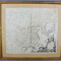
Kaart van China, Korea en de Japanse eilanden, ca 1779

223
Dit lot werd verkocht op 2015-10-12 en is niet meer beschikbaar
| SANTINI, Paolo, L'Empire de la Chine, avec la Tartarie Chinoise d'après l'Atlas Chinois. Venice, Remondini, 1779. Original outline colour. 485 x 560mm. China, Korea and Tartary, also showing Japan and Ezo, published by Santini in conjuction with Rigobert Bonne of Paris. A large title cartouche of Chinese figures and ornaments fills the lower right. Incl. frame: 69 x 62 cm. |
Hamerprijs incl. commissie:
€ 1.912,50